From robotaxis to hands-free driving: The year 2023 has set various milestones in the development of autonomous driving. In addition to aspects such as the safety and sustainability of self-driving technologies, location data is becoming the focus of interest. Data and navigation reliability are the key to further developments in this area. The Navigation Data Standard supports innovations in the field of autonomous driving, as the example of our member HERE shows. Joe Suh, Principal Software Engineer, and Boris Gumhold, Senior Manager of Engineering at HERE and Chairman of the technical committee (TC) for the NDS Association, report on how NDS.Live Services are being used at HERE to take the future of driving to a new level.
As driving becomes increasingly automated, safety and regulatory compliance are essential challenges to overcome. Many new cars already offer some automation such as driver assistance systems (DAS). At the moment, autonomous driving without a physically present driver is only permitted in some approved areas though. However, autonomy will continue to increase step by step. Level 3 and higher autonomous or automated vehicles need to fulfill many technical requirements. Regardless of the level of automation, the automated driving experience should be safe and comply with local traffic regulations. The HERE HD Live Map provides autonomous drivers with additional intelligence to help them drive more safely and predictably within their defined operating area.

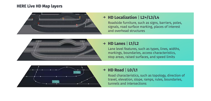
Automated Driving use cases supported by HERE include route planning and fleet management, precise localization of objects, path planning, operational design domain definition under which a vehicle can apply its functions and simulation. There are different layers of the HERE map offering such as core maps with a complete coverage of the worldwide road network, daily updated HD maps for lane and localization map data to fulfill the requirements for automated driving, dynamic services such as lane-level traffic information and hazard warnings, and last but not least private and marketplace maps to add individual maps to the HERE map.
Developers use raw data such as sensor or probe, ADAS or aerial data as well as governmental or seeded manual input for content conflation to gain detailed insights into roads etc. All the different features are then put into content domains to be aligned for a unified view into the content. All this information is needed for the automated driving functions. Millions of cars and sensors contribute to the map development.
Crowdsourced data to precisely locate cars
HERE HD Live Map helps autonomous vehicles understand their precise position and surroundings. It is a highly-detailed, cloud-based map for autonomous systems and updated in near-real time with sensor data from connected vehicles. HERE HD Live Map enables a self-driving vehicle to plan beyond sensor visibility, apply contextual awareness of its environment and process local road rules to make safer and more pro-active driving decisions. In doing so, it brings together critical pieces of the self-driving puzzle to enhance trust in autonomous driving solutions and pave the way for automated driving. The HERE HD Live Map is published in NDS format. “Personal Pilot”, BMW’s Level 3 function for highly automated driving, already uses the Here HD Live Map.
NDS.Live generally offers the following options
In NDS.Live, the Registry Service serves as a gateway to get information about available services, including other registries. NDS.Live’s Smart Layer Service provides layered data for a tile, an object (referenced by ID) and a path in the near future.The Smart Layer Path Horizon Service provides layered data for a horizon based on a provided path. The Smart Layer Mesh Service supports with a pre-packaged set of smart layer tiles. Smart Raster Tile Service gives access to raster images. Furthermore, the Routing Service provides routes based on requested details, whereas the Range Projection Service provides a polygon of a reachable area based on parameters. Additional services in NDS.Live support with search, geocoding and vehicle horizon.
You can log into the NDS.Live Developer Portal to find out more.
Back to news →