Modern navigation is no longer just about getting from point A to point B. With a rapid move toward automated driving, maps need to think, adapt, and respond to real-world conditions. NDS maps leverage a powerful combination of attributes and conditions to model every aspect of the road network and its surroundings, supporting critical functions for intelligent navigation, Advanced Driver Assistance Systems (ADAS), and the next generation of automated driving.
Attributes provide the descriptive basis of an NDS map, covering a wide range of features, from road geometry and lane configurations to traffic signs, speed limits, and points of interest. These details transform a simple line on a map into a rich, data-driven object that can inform route planning, enhance driver safety, and guide autonomous decision-making. At the same time, conditions add the essential layer of context to the map. They define when and under what circumstances an attribute applies, such as whether a road operates as one-way traffic during certain hours or if a lane is temporarily closed for maintenance.
To organize this complexity, NDS uses attribute modules, which define attributes in a generic way and provide dedicated layers for each feature type. Within these layers, attributes can be assigned directly to features through attribute maps or grouped into attribute sets for reuse across multiple features. This flexible structure allows attributes to be paired with additional properties and bound to relevant conditions, ensuring that every piece of information is accurate, relevant, and context-aware.
Some attributes are versatile enough to be applied across similar feature types, such as roads, lanes, or display lines, making it easy to model consistent rules and characteristics. Others are unique to specific elements, like the surface texture of a 3D building model, the accessibility of a public venue, or the multilingual names of a landmark POI. This balance of flexibility and accuracy ensures that NDS maps can serve both broad mobility use cases and highly specialized applications, scaling seamlessly from conventional navigation to the most advanced autonomous driving scenarios.

In NDS maps, attributes and conditions work together to turn simple geospatial data into a dynamic, context-rich representation of the real world. Attributes describe what is presented in the map, while conditions define when, how, or under what circumstances that information applies. Together, they form the foundation of smart mobility systems, enhancing convenience for end users.
Attributes and conditions in NDS maps provide the critical details needed for advanced vehicle functions, from everyday navigation to fully automated driving. They ensure that systems receive accurate, up-to-date, and context-rich information for safer and smarter mobility.
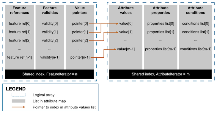
An attribute map is the physical representation of attributes and their assignment to map features. It provides a space-efficient way to store information, since the same attribute can be referenced by multiple features without duplication. This design is especially useful for large-scale maps with recurring attributes, such as speed limits or lane types.
Structurally, an attribute map consists of two logical arrays, each made up of multiple lists that share the same size and implicitly align by index. Each array uses an iterator to link its entries to a specific entity. This approach allows for efficient compression, as the values within each list are of the same type and can be processed collectively.
Two types of iterators organize the attribute map data:
Together, these structures enable attribute maps to store rich, detailed information efficiently while maintaining flexibility for complex use cases in navigation, ADAS, and automated driving.
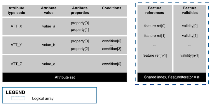
An attribute set is a collection of related attributes that can be assigned together to one or more features via an attribute set map. This approach is particularly efficient when the same combination of attributes applies to many features, as it reduces storage requirements by storing the feature reference only once.
An attribute set map typically includes two key components:
Using attribute sets and set maps allows NDS to manage large-scale, complex map data efficiently while maintaining flexibility and consistency across similar features.
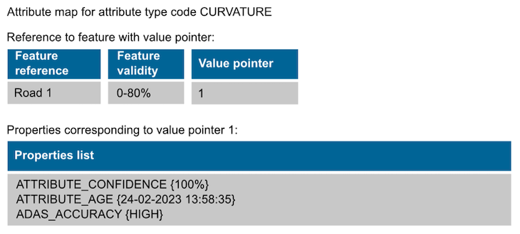
Attribute properties provide supplementary information that enriches the meaning of an attribute. They can include metadata such as the attribute’s age, language code, or accuracy level, helping systems interpret and apply the data correctly. Each property is represented by a type and a corresponding value.
Properties can either be imported from the Core module or defined locally within a specific attribute module, or a combination of both. Examples of locally defined properties include:
A single attribute can have multiple properties, allowing for detailed and context-specific annotation. For instance, an attribute map may use two properties imported from the Core module alongside one property locally defined in the ADAS module. All of these properties are stored together in a single properties list within the attribute map, ensuring efficient organization and easy access.
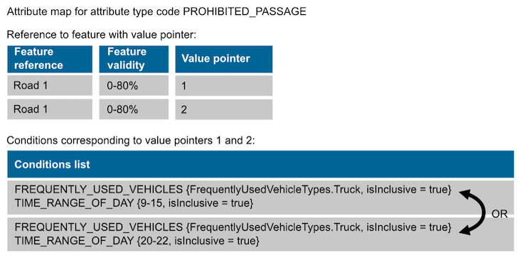
Attribute conditions define the circumstances under which an attribute applies, such as specific times of day, weather conditions, or other contextual factors. Each condition is represented by a type and a value, and a single attribute can have multiple associated conditions.
Within an attribute map, the truth values of conditions in a list are combined using a logical AND after applying the isInclusive value. The result determines whether the attribute is active under the given conditions.
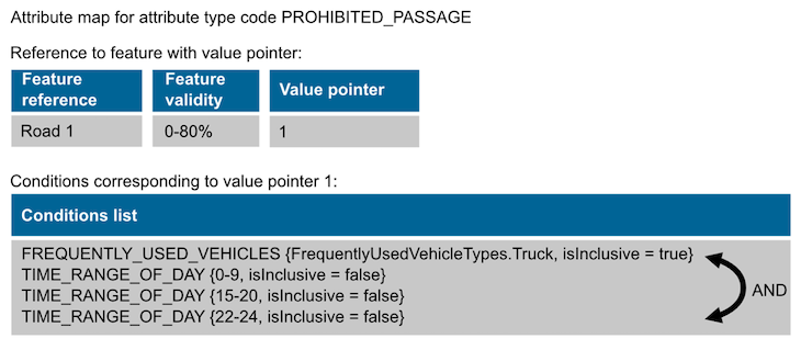
Consider a scenario where a road has a PROHIBITED_PASSAGE attribute for trucks. To determine if the restriction applies, the system evaluates all relevant attributes until one of the following is true:
The figures below illustrate how an attribute map or attribute set can be used to restrict truck access during two specific time ranges: from 9:00 a.m. to 3:00 p.m., and from 8:00 p.m. to 10:00 p.m. In the first example, the two time ranges are modeled using separate conditions lists, with the truth values of the lists logically combined using function OR.
In the second figure, an attribute map models the required time ranges using a single conditions list. Within this list, the truth values of the conditions are combined using a logical AND. To replicate the effect shown in the first figure, the time ranges must be inverted by applying the isInclusive value, which is evaluated before the logical AND operation.
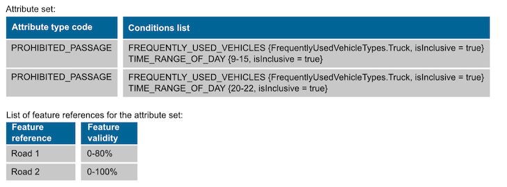
In the third figure, the attribute and its associated conditions are combined within a single attribute set, similar to how they are represented in the attribute map of the first figure.
In NDS maps, attributes can be paired with conditions to model complex, real-world regulations that vary by time, vehicle type, or other contextual factors. By combining multiple conditions and applying the isInclusive value where needed, these rules can be represented with precision, enabling navigation and automated driving systems to respond appropriately in diverse situations.
Road closed for trucks on weekends
An attribute with conditions specifies that truck movement is prohibited on Saturdays and Sundays.
Only emergency vehicles allowed
An attribute with conditions restricts access to all motorized vehicles except emergency vehicles.
Road closed for a specific time range each month
An attribute with conditions prohibits all vehicle types from the 1st to the 10th day of each month, except between 6:00 a.m. and 10:00 a.m.
Overtaking prohibition
An attribute with conditions bans overtaking for trucks, buses, and cars with trailers between 6:00 a.m. and 8:00 p.m.
Lane closed for cars and trucks during rush hour
An attribute with conditions limits lane usage to school buses, public buses, and bicycles from Monday to Friday between 7:30 a.m.–9:30 a.m. and 4:30 p.m.–6:30 p.m. At all other times, the lane is open to all road users.
Road closed for trucks and motorcycles depending on day of week
From Monday to Friday, a road in a small village is closed to trucks weighing more than 8 tons, wider than 3 meters, or taller than 4 meters. On weekends, the same road is closed to motorcycles and to vehicles weighing more than 2.8 tons or longer than 8 meters. This regulation does not apply to buses. All corresponding attributes and conditions are assigned to the road.
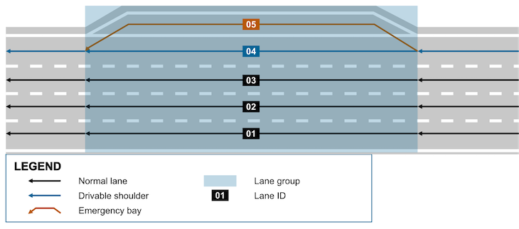
Motorway with drivable shoulder lane
The lane group that includes the emergency bay consists of five lanes: lanes 1 to 3 are standard traffic lanes; lane 4 is a drivable shoulder lane that may only be used in emergencies; lane 5 is the emergency bay itself. In this example, the prohibition for slow road users is explicitly modeled but could also be implemented using region rules.
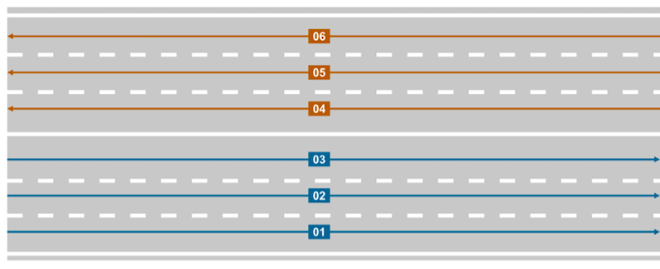
Bidirectional lane group
This example models a regular road lane group covering all lanes from curb to curb. Each direction has three lanes, with bicycles and pedestrians prohibited. All lanes are digitized in the travel direction: lanes 1 to 3 from left to right, and lanes 4 to 6 from right to left. As a result, all lanes share the same attributes.
Opening Hours of POI
A POI is open from Monday to Thursday between 10:00–12:00 and 14:00–18:00. Two separate attributes are required because conditions within the attributeConditions list of an attribute map are combined using a logical AND. Any boolean values of the following conditions that are not explicitly mentioned are set to false.
Conditions for hybrid vehicles and electric vehicles
NDS.Live does not provide a dedicated ENERGY_TYPE value for hybrid vehicles. To model conditions that apply exclusively to hybrids, we should combine two ENERGY_TYPE conditions using a logical AND – one with the value GASOLINE and one with the value ELECTRICITY. When evaluating the condition bitmask, the application first applies the isInclusive value and then interprets the energy values. The required combination depends on whether a prohibition or a permission is being modeled. The following examples demonstrate how the two ENERGY_TYPE values are combined within the corresponding attribute map.
Environmental zone for electric and hybrid vehicles only
In this scenario, an environmental zone is accessible only to electric and hybrid vehicles, with access prohibited for all other vehicle types.
Since the energy type ELECTRICITY with isInclusive=false allows only electric and hybrid vehicles to use the road, a single condition in the attribute map is sufficient to model this rule.
Environmental zone for hybrid vehicles only
Here, the environmental zone is accessible exclusively to hybrid vehicles, with access prohibited for all other vehicle types. Because the energy type ELECTRICITY with isInclusive=false excludes both electric and hybrid vehicles, an additional condition is required to allow only hybrid vehicles. In this case, two conditions are stored in the same conditions list of the attribute map and combined using a logical AND.
Environmental zone for electric vehicles only
An environmental zone may only be used by electric vehicles. Access for all other vehicle types is prohibited. Because the energy type ELECTRICITY with isInclusive=false allows both hybrid and electric vehicles, a second condition is added in the attribute map to include hybrid vehicles in the prohibition. The conditions are combined using a logical AND because they are stored in the same conditions list.
In essence, NDS offers a flexible and powerful framework for managing map data, allowing applications to seamlessly use attributes and conditions to support safe, efficient navigation and automated driving. This capability makes it easier for developers to adapt maps to various use cases and vehicle requirements.
To learn more about how NDS maps use attributes and conditions for intelligent navigation, visit the NDS Developer Portal.
Back to news →